Project Manager(s):
Fang Zhao (fang.zhao@smart.mit.edu)
Sponsor:
Singapore-MIT Alliance for Research and Technology (SMART)
Team:
Fang Zhao, Kyungsoo Jeong, Moshe Ben-Akiva, Christopher Zegras, Linlin You, William Ko, Christina Lui and Trung Hieu DAO
Research Affiliates :
Ajinkya Ghorpade, Francisco Pereira, Bilge Atasoy, Ines Dias, Jorge Santos, Kalan Vishwanath, William Ko, Zhengquan Qin and Paola Garbagnoli
Start Date:
July 2011
Research Highlights:
Next generation travel survey system that leverages
- increasingly pervasive smartphone ownership
- advanced sensing technologies
- machine learning techniques
to deliver previously unobtainable range of behavioral data and insights.
Abstract:
Future Mobility Sensing (FMS) is a smartphone and prompted-recall-based integrated activity-travel survey. It uses a combination of a smartphone app, available for Android and iOS, and an online prompted recall survey to collect both demographic and travel data from participants. Data collected from the smartphone app are uploaded to a central server, mapped, analyzed, and made accessible to the participant from the project website, where he or she is asked to provide detailed travel information via a prompted-recall survey. The detailed, accurate data collected by FMS can be used for transportation modeling and urban planning.
Description:
Traditional paper-based travel surveys are limited in amount and accuracy of data they collect. As smartphones are becoming ubiquitous nowadays, they are ideal “life-loggers”. In this project, we explore the applicability of smartphones for conducting large-scale, user-directed travel surveys.
The Future Mobility Sensing (FMS) is a smartphone-based integrated activity-travel survey. It uses a combination of a smartphone app, available for Android and iOS, and an online prompted recall survey to collect both demographic and travel data from participants. Data collected from the smartphone app are uploaded to a central server, mapped, analyzed, and made accessible to the participant from the project website, where he or she is asked to provide detailed travel information via a prompted-recall survey. The detailed, accurate data collected by FMS can be used for transportation modeling and urban planning.
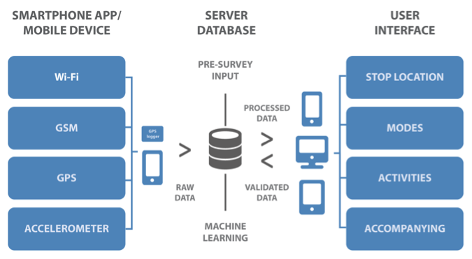
Figure 1. FMS architecture
Challenges:
The goal of the FMS project is to draw upon technology innovations to design and implement an integrated smartphone/server/web interface platform that is:
- Non-intrusive, interactive and end user friendly;
- Does not require special purpose equipment or regular face-to-face interaction; and
- Allows for detailed data collection.
For the smartphone app, a crucial challenge is battery consumption, mainly due to the use of the GPS sensor. Effectively, this can become the major source of burden for participants while recording their trips and activities. We want to strike a balance between battery consumption and the quality of collected data.
In the backend, in order to reduce user burden when completing the online prompted-recall survey, we design algorithms to infer users’ stops, modes of transportation, and activity types based on the raw data uploaded from their smartphones and users’ past validations. These algorithms need to be robust, as we do not have always have “perfect” raw data due to unavailability of GPS data, inaccuracy of location data, restrictions due to battery consumption etc.
Finally, as there is no face-to-face interaction in this survey, it is crucial to design a web-based activity diary that is intuitive, self-explanatory, and has minimal user burden. The notion of activity diary is somewhat strange to the layman, thus the first difficulty of any regular user is simply to understand what to do. We note that, to properly fill the activity diary (i.e. to validate their data), the user needs to verify the following information:
- Stop locations
- Stop durations (start and end time)
- Activities performed in those locations
- Travel modes taken between stops
- Costs/options associated with travel modes such as bus number, parking cost or accompanying persons
A major design challenge is thus to communicate what each concept means, explain each individual task and options, as well as prompt the user with visual and textual cues to recall the actual activities and travel.
Smartphone app
The key role of the smartphone device in our project is to act as data loggers. In fact, the overall FMS platform is being implemented to allow other types of devices to upload data to the server, such as dedicated GPS loggers or On-Board Diagnostic (OBD) devices. Thus, our app is deliberately “silent” in the sense that nothing at all is expected from the user besides making sure it is running.

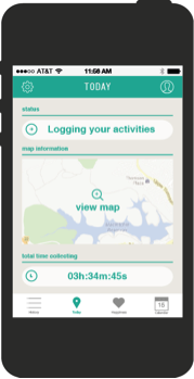

Figure 2. Smartphone App Interface
Download the app on Android and iOS
Data analysis
The data analysis component serves to transform the logged raw data into understandable information for the user. It is particularly focused on inferring activity locations, transportation modes and activities.
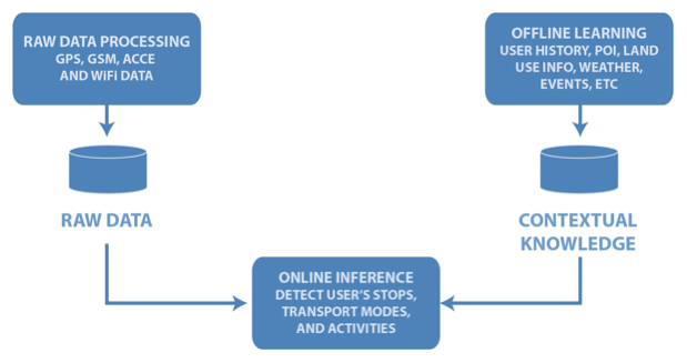
Figure 3. Data analysis component
For “stop inference”, we apply a rule-based algorithm in two phases: first, it matches spatial/temporal windows to the data to obtain candidate stops; then, it uses wifi, GSM, and accelerometer data to merge stops, particularly using accelerometer information to detect “still” periods (where, although the GSM is “jumping”, the user should stay in the same place). It also uses past validation information to match user’s recurrent places (e.g., home, work) with GSM signatures and adds/removes stops based on mode detection results (e.g. there must be a stop for change mode/transfer between any two different modes). The “mode inference” step applies a machine-learning algorithm to accelerometer and GPS data to identify the mode out of the set of car, bus, subway, walk, bicycle or motorbike. Finally, the “activity inference” matches the historical data, namely the previous validations, to current stops to identify recurrent locations. We are currently developing an integrated stop/mode detection algorithm based on machine-learning techniques.
Web interface
The third component of our system is the web interface. To collect high quality validated data, it is important to make the validation process intuitive and simple for all users, however, many new users find this process challenging. To this end, we carried out several rounds of usability tests, and are continuously working on improving our interface design based on user feedback. In addition, we development a remote desktop help system based on the Firefly® technology. With this feature, the user can share his browser window with the FMS helpdesk assistant, which enables the assistant to better understand his issue and guide him through the validation process.
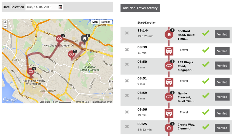
Figure 4. Activity diary.
Field test:
FMS has been successfully field tested in Singapore in conjunction with Singapore Land Transport Authority’s (LTA’s) Household Interview Travel Survey (HITS 2012). More than 1500 HITS participants also participated in FMS demonstration project between October 2012 and September 2013. Compared to conventional paper based surveys like HITS, FMS can deliver substantially richer, higher resolution and large travel and activity dataset.
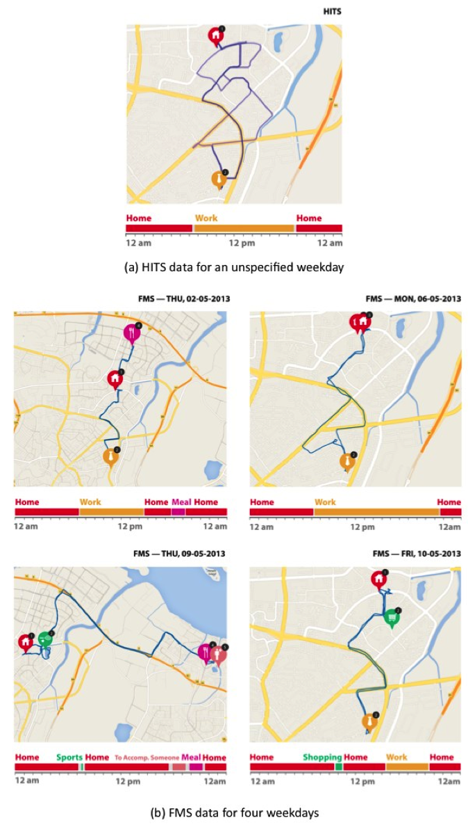
Figure 5. HITS and FMS data from the same users on different days
References:
- F. Zhao, F. C. Pereira, R. Ball, Y. Kim, Y. Han, C. Zegras, and M. Ben-Akiva, “Exploratory analysis of a smartphone-based travel survey in Singapore,” Transportation Research Records: Journal of the Transportation Research Board.
- C. Carrion, F. C. Pereira, R. Ball, F. Zhao, Y. Kim, K. Nawarathne, N. Zheng, C. Zegras, and M. Ben-Akiva, “Evaluating FMS: A preliminary comparison with a traditional travel survey,” the 93rd Annual Meeting of the Transportation Research Board (TRB ’14).
- C. Cottrill, F. Pereira, F. Zhao, I. Dias, H. B. Lim, M. Ben-Akiva, and C. Zegras, “Future Mobility Survey: Experience in Developing a Smart-Phone-Based Travel Survey in Singapore”, Transportation Research Record: Journal of the Transportation Research Board, issue 2354, pp 59-67, 2013.